NAVIGATION / MULTI INFO DISPLAY NAVIGATION SYSTEM(for Gasoline Model with RST Switch) SYSTEM DESCRIPTION
NAVIGATION SYSTEM OUTLINE
Vehicle position tracking methods
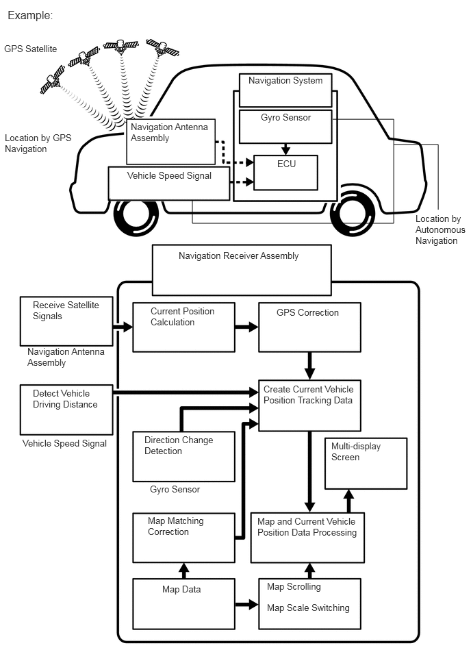
It is essential that the navigation system correctly tracks the current vehicle position and displays it on the map. There are 2 methods to track the current vehicle position: autonomous (dead reckoning) and GPS* (satellite) navigation. Both navigation methods are used in conjunction with each other.
*: GPS (Global Positioning System)
| Operation | Description |
|---|---|
| Vehicle Position Calculation | The navigation receiver assembly calculates the current vehicle position (direction and current position) using the direction deviation signal from the gyro sensor and driving distance signal calculated from the vehicle speed signal and creates the driving route. |
| Map Display Processing | The navigation receiver assembly processes the vehicle position data, vehicle driving track and map data from the internal memory. |
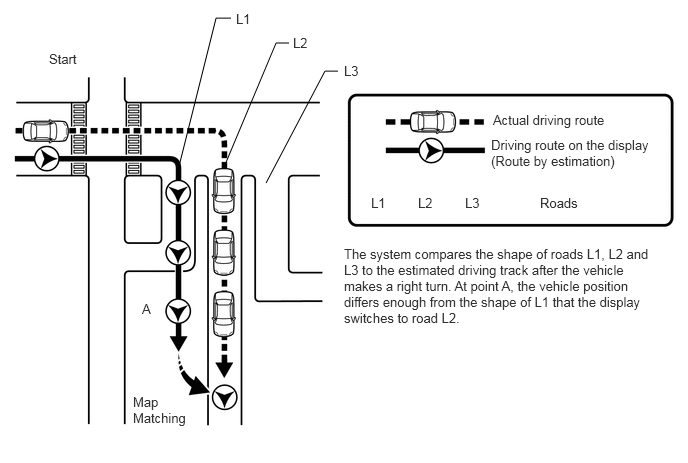
| Map Matching | The map data from the internal memory is compared to the vehicle position and driving track data. Then, the vehicle position is matched with the nearest road. |
| GPS Correction | The vehicle position is matched to the position measured by the GPS. Then, the GPS measurement position data is compared with the vehicle position and driving track data. If the position is very different, the GPS measurement position is used. |
| Distance Correction | The vehicle speed signal includes errors caused by tire wear. Distance correction is performed to account for this. The navigation receiver assembly automatically offsets the signal to make up for the difference between it and the distance data of the map. The offset is automatically updated. |
- HINT:
-
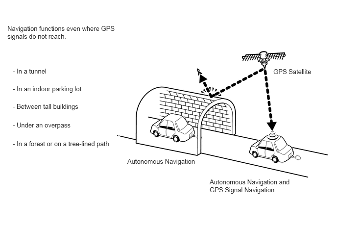
The combination of autonomous and GPS navigation makes it possible to display the vehicle position even when the vehicle is in places where GPS signals cannot be received. When only autonomous navigation is used, however, the mapping accuracy may slightly decrease.
Autonomous navigation
This method determines the relative vehicle position based on the driving track determined by the gyro sensor located in the navigation receiver assembly and the vehicle speed signal.
Gyro sensor
Used to calculate the direction by detecting angular velocity. It is located in the navigation receiver assembly.
Vehicle speed signal
Used to calculate the vehicle driving distance.
GPS* navigation (Satellite navigation)
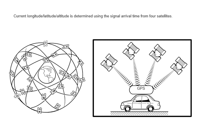
This method detects the absolute vehicle position using radio waves from GPS satellites.
*: GPS satellites were launched by the U.S. Department of Defense for military purposes.
| Number of Satellites | Measurement | Description |
|---|---|---|
| 2 or less | Measurement is impossible | Vehicle position cannot be obtained because the number of satellites is not enough. |
| 3 | 2-dimensional measurement is possible | Vehicle position is obtained based on the current longitude and latitude. (This is less precise than 3-dimensional measurement.) |
| 4 | 3-dimensional measurement is possible | Vehicle position is obtained based on the current longitude, latitude and altitude. |
Map matching
The current driving route is calculated by autonomous navigation (according to the gyro sensor and vehicle speed signal) and GPS navigation. This information is then compared with possible road shapes from the map data in the internal memory and the vehicle position is set onto the most appropriate road.
Hand-writing Input Function
On the facility name (Pin Yin) search and the address/intersection search during a destination search, besides a keyboard input method, a hand-writing input method is supported. Characters can be entered by writing a character with a finger on the input zone of the multi-display. Additionally, this method has the character prediction function that predicts and displays potential matches when the user starts writing the character on the input zone.
Update the Map Database
The map database stored in the internal memory can be updated via the network.
The map database on the server is updated twice per year.
Two types of map database updates are available and the way to update differs for each area.
| Update Type | Update Method | Update Area |
|---|---|---|
| Offline Update (for USB Memory) | Using the information downloaded to a USB memory device, the internal memory of the navigation receiver can be updated. | Entire stored map database or selected areas |
| Offline Update (for Smartphone Link) | Using the information downloaded to a smartphone, the internal memory of the navigation receiver can be updated when the smartphone is connected. | Entire stored map database or selected areas |
| Online Update | Performed by operating the multi-display of the navigation receiver assembly using Wi-Fi communication. | Selected areas |
USB VIDEO SYSTEM FUNCTION OUTLINE
The No. 1 stereo jack adapter assembly is equipped with a USB connector. Connecting a USB device to the No. 1 stereo jack adapter assembly allows video files to be played. Not only is it possible to play video from a USB device with video functions, it is also possible to play MPEG-4 or H.264 video files that are stored on a USB device.
- HINT:
-
Operation through the controls of a USB device cannot be performed while it is connected.
Playable video file standards
| File extension | Compatible frame rates |
|---|---|
| .avi | Maximum 1080 p/30 fps |
| .mp4 | |
| .3gp |
File names
Only files with an extension of ".avi", ".mp4", and ".3gp" can be recognized and played as MPEG-4 or H.264 files.
Save MPEG-4 or H.264 files with an extension of ".avi", ".mp4", or ".3gp".
- NOTICE:
-
If non-MPEG-4 or non-H.264 files are saved with an extension of ".avi", ".mp4", or ".3gp", those files may be wrongly recognized as MPEG-4 or H.264 files and played. A loud noise may occur and damage to the speakers may result.
USB PICTURE SYSTEM FUNCTION OUTLINE
The No. 1 stereo jack adapter assembly is equipped with a USB connector. Connecting a USB device to the No. 1 stereo jack adapter assembly allows picture files to be displayed. Not only is it possible to display pictures from a USB device with picture functions, it is also possible to display JPEG, BMP, PNG, TIF or GIF picture files that are stored on a USB device.
- HINT:
-
Operation through the controls of a USB device cannot be performed while it is connected.
Playable picture file standards
| File extension | Compatible picture size |
|---|---|
| .jpeg | Maximum 5248 x 3936 pixels |
| .bmp | |
| .png | |
| .tif | |
| .gif |
File names
Only files with an extension of ".jpeg", ".bmp", ".png", ".tif", and ".gif" can be recognized and played as JPEG, BMP, PNG, TIF or GIF files.
Save JPEG, BMP, PNG, TIF or GIF files with an extension of ".jpeg", ".bmp", ".png", ".tif", or ".gif".
- NOTICE:
-
If non-JPEG, non-BMP, non-PNG, non-TIF or non-GIF files are saved with an extension of ".jpeg", ".bmp", ".png", ".tif", or ".gif", those files may be wrongly recognized as JPEG, BMP, PNG, TIF or GIF files and played.
USB AUDIO SYSTEM FUNCTION OUTLINE
The No. 1 stereo jack adapter assembly is equipped with a USB connector. Connecting a USB device to the No. 1 stereo jack adapter assembly allows music files to be played. Not only is it possible to play music from a USB device with audio functions, it is also possible to play MP3, WMA, AAC, WAV (LPCM), FLAC or APE music files that are stored on a USB device.
- HINT:
-
Operation through the controls of a USB device cannot be performed while it is connected.
USB audio system compatible devices
USB device
The following device formats can be used:
| Compatible USB device formats | ·
USB communication format: USB 2.0 HS (480 Mbps) and FS (12 Mbps) ·
File format: FAT32 (Windows) ·
Class: Mass storage class |
MP3, WMA, AAC, WAV (LPCM), FLAC or APE files written to a USB device with any format other than those listed above may not be played correctly, and their names and folder names may not be displayed correctly.
Items related to standards and limitations are as follows:
Maximum directory hierarchy: 8 levels
Maximum number of folders in device: 2000 (including the root folder)
Maximum number of files in device: 2000
"iPod"
"iPhone", "iPod nano" and "iPod touch" are trademarks of Apple Inc., registered in the U.S. and other countries.
The following "iPhone", "iPod nano" and "iPod touch" devices can be used with this system.
Made for:
"iPod touch" (6th generation)
"iPod touch" (5th generation)
"iPod nano" (7th generation)
"iPhone 5s"
"iPhone 6"
"iPhone 6 Plus"
"iPhone SE"
"iPhone 6s"
"iPhone 6s Plus"
"iPhone 7"
"iPhone 7 Plus"
"iPhone 8"
"iPhone 8 Plus"
"iPhone X"
"iPhone XR"
"iPhone XS"
"iPhone XS Max"
- HINT:
-
Depending on differences between models or software versions, etc., some models might be incompatible with this system.
FILE INFORMATION OUTLINE
Playable MP3 file standards
| Compatible standard | MPEG1 (Layer3), MPEG2 (Layer3), MPEG2 LSF (Layer3) |
| Compatible sampling frequency | ·
MPEG1 (Layer3): 32, 44.1, 48 (kHz) ·
MPEG2 (Layer3): 32, 44.1, 48 (kHz) ·
MPEG2 LSF (Layer3): 16, 22.05, 24 (kHz) |
| Compatible bit rate | ·
MPEG1 (Layer3): 32 to 320 (kbps) ·
MPEG2 (Layer3): 32 to 320 (kbps) ·
MPEG2 LSF (Layer3): 8 to 160 (kbps) ·
Compatible with VBR |
| Compatible channel mode | Stereo, joint stereo, dual channel, monaural |
Playable WMA file standards
| Compatible standard | Ver. 7, 8, and 9 |
| Compatible sampling frequency | 32, 44.1, 48 (kHz) |
| Compatible bit rate (Only compatible with 2-channel playback) | ·
Ver. 7, 8: CBR 48 to 192 (kbps) ·
Ver. 9: CBR 48 to 320 (kbps) ·
Compatible with VBR |
| Compatible channel mode | Stereo, monaural |
Playable AAC file standards
| Compatible standard | AAC-LC |
| Compatible sampling frequency | 11.025/12/16/22.05/24/32/44.1/48 (kHz) |
| Compatible bit rate | ·
16 to 320 (kbps) ·
Compatible with VBR |
| Compatible channel mode | 5.1 Channels or less |
Playable WAV (LPCM) file standards*
| Compatible standard | Linear-PCM |
| Compatible sampling frequency | 8/11.025/12/16/22.05/24/32/44.1/48/88.2/96/176.4/192 (kHz) |
| Compatible bit rate | 16/24 (bit) |
| Compatible channel mode | Mono, Stereo |
*: Files with a sample rate higher than 48kHz are down-converted to 48kHz/16bit.
Playable FLAC file standards*
|
*: Files with a sample rate higher than 48kHz are down-converted to 48kHz/24bit. |
|
| Compatible sampling frequency | 8/11.025/12/16/22.05/24/32/44.1/48/88.2/96/176.4/192 (kHz) |
| Compatible bit rate | 16/24 (bit) |
Playable APE file standards
| Compatible sampling frequency | 8/11.025/12/16/22.05/24/32/44.1/48/88.2/96/176.4/192 (kHz) |
| Compatible bit rate | 16/24 (bit) |
ID3 tag, WMA tag, AAC tag, APE tag and TAG comment
Additional text information called an ID3 tag can be input to MP3 files. Information such as song titles and artist names can be stored.
- HINT:
-
This player is compatible with ID3 tags of ID3 Ver. 1.0 and 1.1, and ID3 Ver. 2.2 and 2.3. (Number of characters complies with ID3 Ver. 1.0 and 1.1, and ID3 Ver. 2.2 and 2.3.)
Additional text information called a WMA tag can be input to WMA files. Information such as song titles and artist names can be stored.
Additional text information called an AAC tag can be input to AAC files. Information such as song titles and artist names can be stored.
Additional text information called an APE tag can be input to APE files. Information such as song titles and artist names can be stored.
Additional text information called a TAG can be input to WAV (LPCM), FLAC files. Information such as song titles and artist names can be stored.
Usable media
Only USB devices can be used to play MP3, WMA, AAC, WAV (LPCM), FLAC or APE files.
File names
Only files with an extension of ".mp3", ".wma", ".m4a", ".wav", ".flac" and ".ape" can be recognized and played as MP3, WMA, AAC, WAV (LPCM), FLAC or APE files.
Save MP3, WMA, AAC, WAV (LPCM), FLAC or APE files with an extension of ".mp3", ".wma", ".m4a", ".wav", ".flac" or ".ape"
- NOTICE:
-
If non-MP3, non-WMA, non-AAC, non-WAV (LPCM), non-FLAC or non-APE files are saved with an extension of ".mp3", ".wma", ".m4a", ".wav", ".flac" or ".ape", those files may be wrongly recognized as MP3, WMA, AAC, WAV (LPCM), FLAC, or APE files and played. A loud noise may occur and damage to the speakers may result.
"Bluetooth" OUTLINE
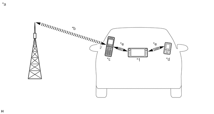
| *1 | Navigation Receiver Assembly
(Built-in "Bluetooth" Antenna) |
- | - |
| *a | Example | *b | Cellular Network |
| *c | Cellular Phone
("Bluetooth" Compatible Type) |
*d | Portable Audio Player
("Bluetooth" Compatible Type) |
| *e | "Bluetooth" Wireless Connection | - | - |
"Bluetooth" is a trademark owned by Bluetooth SIG, Inc.
"Bluetooth" is a wireless connection technology that uses the 2.4 GHz frequency band.
- HINT:
-
The communication performance of "Bluetooth" may vary depending on obstructions or radio wave conditions between communication devices, electromagnetic radiation, communication device sensitivity or antenna capacity.
Hands-free function
The "Bluetooth" built-in navigation receiver assembly and a "Bluetooth" compatible cellular phone* can be connected using a "Bluetooth" wireless connection. This enables the use of the hands-free function on the cellular phone even if the phone is in a pocket or bag. For this reason, it is not necessary to use a connector or cable to connect the cellular phone.
*: Some versions of "Bluetooth" compatible cellular phones may not function properly.
The hands-free function uses a "Bluetooth" wireless connection. A "Bluetooth" wireless connection can be affected by uncertain elements, such as vehicle location, time of day, etc. Therefore, problems related to establishing connection may be caused temporarily by "Bluetooth" connection conditions. It is necessary to check the frequency of occurrence, connection conditions using another cellular phone, etc. when performing diagnosis.
Compatible hands-free devices
| Required "Bluetooth" specifications | Ver. 4.0 or higher |
| Compatible profiles | ·
HFP (Hands-Free Profile) Ver. 1.5 or higher*1 ·
PBAP (Phone Book Access Profile) Ver. 1.0 or higher*1 ·
SPP (Serial Port Profile) Ver. 1.1 or higher*2 |
| Maximum number of hands-free devices that can be registered (including audio devices) | 5 |
| Required "Bluetooth" specifications | Ver. 4.2 or higher |
| Compatible profiles | ·
HFP (Hands-Free Profile) Ver. 1.7 or higher*1 ·
PBAP (Phone Book Access Profile) Ver. 1.2 or higher*1 ·
SPP (Serial Port Profile) Ver. 1.2 or higher*2 |
| Maximum number of hands-free devices that can be registered (including audio devices) | 5 |
*1: This profile is necessary when using the hands-free function.
*2: This profile is necessary when using the G-BOOK system.
- HINT:
-
The amount of remaining battery charge displayed on the navigation receiver assembly may be different from that of the "Bluetooth" device.
"Bluetooth" audio function
The "Bluetooth" built-in navigation receiver assembly and a "Bluetooth" compatible portable audio player* can be connected using a "Bluetooth" wireless connection. This enables files stored in the portable audio player to be heard from the vehicle speakers. In addition, operations such as play/stop can be performed directly from the navigation receiver assembly.
*: Some versions of "Bluetooth" compatible audio players may not be able to be connected via the "Bluetooth" function, or music may play, but functions available using the navigation receiver assembly may be limited.
Compatible "Bluetooth" audio devices
| Required "Bluetooth" specifications | Ver. 4.0 or higher |
| Compatible profiles | ·
A2DP (Advanced Audio Distribution Profile) Ver. 1.2 or higher ·
AVRCP (Audio/Video Remote Control Profile) Ver. 1.4 or higher |
| Maximum number of audio devices that can be registered (including hands-free devices) | 5 |
| Required "Bluetooth" specifications | Ver. 4.2 or higher |
| Compatible profiles | ·
A2DP (Advanced Audio Distribution Profile) Ver. 1.3 or higher ·
AVRCP (Audio/Video Remote Control Profile) Ver. 1.6 or higher |
| Maximum number of audio devices that can be registered (including hands-free devices) | 5 |
- HINT:
-
The amount of remaining battery charge displayed on the navigation receiver assembly may be different from that of the "Bluetooth" device.
RADIO DESCRIPTION
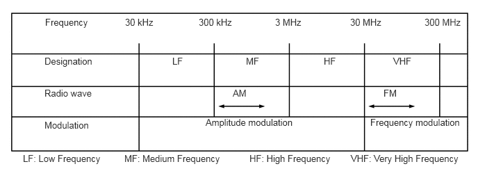
Radio frequency band
Radio broadcasts use the radio frequency bands shown in the table below.
Service area
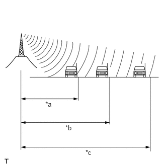
| *a | FM (Stereo) |
| *b | FM (Monaural) |
| *c | AM |
The service areas of AM and FM broadcasts are vastly different. Sometimes an AM broadcast can be received very clearly but an FM stereo broadcast cannot. FM stereo has the smallest service area, and is prone to pick up static and other types of interference such as noise.
Radio reception problems
- HINT:
-
In addition to static, other problems such as "phasing", "multipath" and "fade out" exist. These problems are not caused by electrical noise, but by the radio signal propagation method itself.
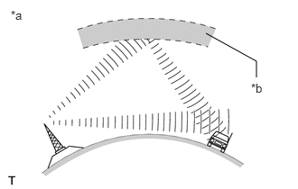
| *a | Phasing |
| *b | Ionosphere |
Phasing
AM broadcasts are susceptible to electrical interference and another kind of interference called phasing. Occurring only at night, phasing is the interference created when a vehicle receives 2 radio wave signals from the same transmitter. One signal is reflected off the ionosphere and the other signal is received directly from the transmitter.
| *a | Multipath |
Multipath
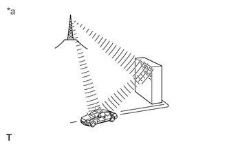
Multipath is a type of interference created when a vehicle receives 2 radio wave signals from the same transmitter. One signal is reflected off buildings or mountains and the other signal is received directly from the transmitter.
| *a | Fade Out |
Fade out
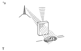
Fade out is caused by objects (buildings, mountains and other large obstructions) that deflect part of a signal, resulting in a weaker signal when the object is between the transmitter and vehicle. High frequency radio waves, such as FM broadcasts, are easily deflected by obstructions. Low frequency radio waves, such as AM broadcasts, are less likely to be deflected.
Noise problem
Technicians must have a clear understanding about each customer's noise complaint. Use the following table to diagnose noise problems.
| Radio Frequency | Noise Occurrence Condition | Presumable Cause |
|---|---|---|
| AM | Noise occurs in a specific area | Foreign noise |
| Noise occurs when listening to an intermittent broadcast | An identical program transmitted from multiple towers can cause noise where the signals overlap | |
| Noise occurs only at night | Signal phasing | |
| FM | Noise occurs while driving in a specific area | Multipath resulting from a change in FM frequency |
"Baidu CarLife" FUNCTION OUTLINE (w/ "Baidu CarLife" Function)
The "Baidu CarLife" function is a function that enables the head unit to operate applications on a smartphone by connecting the smartphone to the head unit using a dedicated cable.
- HINT:
- ·
Refer to the owner's manual included with the device for information about "Baidu CarLife" support.
·Some applications have a display restriction in consideration of safe driving.
COMMUNICATION SYSTEM
CAN Communication Outline
The navigation system uses CAN communication between the navigation receiver assembly and ECUs.
COMMUNICATION BASED VOICE RECOGNITION FUNCTION OUTLINE
There are two types of voice recognition; the voice recognition function uses voice recognition data stored in the onboard device. The other is communication based and uses voice recognition data sent from communication with the telematics transceiver as audio signals to be stored at the center.
- HINT:
-
Refer to the Telematics System for information about communication based voice recognition.
QQ MUSIC FUNCTION OUTLINE
QQ Music is a streaming application managed by Tencent.
Refer to http://y.qq.com for details.
Ximalaya FM FUNCTION OUTLINE
Ximalaya FM is a shared platform of music content managed by Ximalaya.com.
Refer to https://www.ximalaya.com for details.
Car-Home Link FUNCTION OUTLINE (w/ Car-Home Link Function)
a. Using the voice recognition function or touch function, smart household appliances can be operated remotely.
- NOTICE:
-
The Car-Home Link Function does not support smart household appliances that may cause a fire if operated remotely.